Kamikochi to Yarigadake via Daikiretto
Challenging 34.3 KM Multi Day Loop
3,336 m ⬈ 3,336 m ⬊


Overview
One of the most popular hiking destinations in Japan is Kamikochi, a pristine mountain valley located in the heart of the Japanese Alps. Kamikochi offers visitors breathtaking views of soaring peaks, glistening alpine lakes, and pristine forests. For those who are looking for a challenge and want to experience the best of what Kamikochi has to offer, hiking from Kamikochi to Yarigadake is an excellent option. This strenuous hike takes you through stunning alpine landscapes, with breathtaking views of the surrounding mountains and valleys.
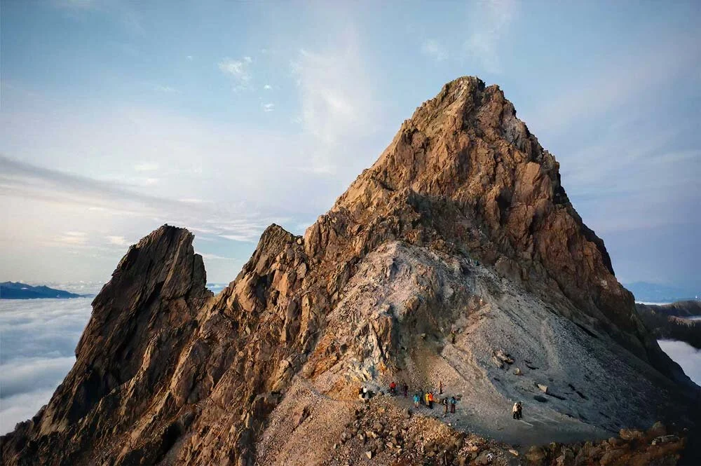
Yarigadake is the fifth-highest peak in Japan, standing at an elevation of 3,180 meters. It is located in the Northern Japan Alps and is considered one of the most challenging hikes in the region. The hike from Kamikochi to Yarigadake covers a distance of around 16 kilometers one way and takes approximately 10 hours to complete. The hike is recommended for experienced hikers and requires good physical fitness, as the trail is steep and rocky in places.
The hike begins at Kamikochi, which is located at an altitude of 1,500 meters. The trail follows the Azusa River, which is fed by melting snow and glaciers from the surrounding mountains. The river is crystal clear, and the sound of rushing water is a constant companion throughout the hike.
The first part of the hike is relatively easy, and the trail is well-maintained. However, as you gain elevation, the trail becomes steeper and more challenging. The scenery also becomes more spectacular, with stunning views of snow-capped peaks and lush alpine forests.
The highlight of the hike is the climb up to Yarigadake, which is steep and demanding plus involved the use of climbing metal ladders and chains. However, the effort is well worth it, as the views from the summit are truly breathtaking. On a clear day, you can see all the way to Mount Fuji.
-
Train
Take the JR Chuo Line (Rapid) from Tokyo Station to Ome Station. The journey takes approximately 1 hour and 10 minutes and costs around 950 yen.
From Ome Station, take the bus bound for Mitake Station and get off at the last stop, Mitake Station. The journey takes approximately 30 minutes and costs around 470 yen.
From Mitake Station, walk to the Mitake Cable Car Station and take the cable car to the Mount Mitake summit. The journey takes approximately 6 minutes and costs around 570 yen.
Bus
Take a direct bus from Shinjuku Station to the Mitake Cable Car Station. The bus journey takes approximately 2 hours and costs around 1,500 yen.
-
Cable Car: The Mitake Tozan Railway is a cable car that runs from the base of the mountain to the top. The ride takes about 6 minutes and offers stunning views of the surrounding scenery.
Hiking: Mount Mitake is a popular destination for hikers, with many trails of varying difficulty levels. The most popular trail is the 4.5 km long trail that leads from the cable car station to the Musashi Mitake Shrine at the top of the mountain.
Weather: The weather on Mount Mitake can be quite changeable, so it's a good idea to check the forecast before you go. The mountain is generally cooler than the surrounding areas, and temperatures can drop quickly as you climb higher.
Facilities: There are several facilities on Mount Mitake, including restaurants, souvenir shops, and restrooms. The Musashi Mitake Shrine also offers lodging for visitors who wish to stay overnight.
Cultural Attractions: Mount Mitake is home to many temples and shrines that are still actively used for worship today. Visitors can also experience the practice of Shugendo, a form of mountain asceticism that combines elements of Shinto, Buddhism, and Taoism.
-
Mount Mitake is a beautiful and scenic mountain located in the western part of Tokyo, Japan. It is part of the Chichibu-Tama-Kai National Park, which is known for its stunning natural beauty and rich biodiversity.
The mountain is covered with dense forests of Japanese cedar, oak, and other native trees, and is home to a variety of wildlife, including monkeys, deer, and birds such as pheasants and eagles. The mountain's numerous streams and waterfalls provide habitats for fish and other aquatic creatures.
One of the most prominent features of Mount Mitake is the Mitake Gorge, a deep and narrow gorge that was formed by the Mitake River. The gorge is a popular destination for tourists and hikers, who come to admire the breathtaking scenery and take in the fresh mountain air.
-
Mount Mitake is a mountain located in the western part of Tokyo, Japan. The mountain has been considered a sacred place for over a thousand years and has a long history.
The earliest recorded history of Mount Mitake dates back to the 8th century, during the Nara period (710-794). According to legend, the mountain was the site of a battle between the gods of the Shinto religion, who were led by the god of thunder, and the demons of the Buddhist religion, who were led by the demon king. The gods were victorious and the mountain became a sacred site for Shinto worship.
During the Heian period (794-1185), Mount Mitake was used as a training ground for Shugendo, a form of mountain asceticism that combines elements of Shinto, Buddhism, and Taoism. The mountain became an important center for the practice of Shugendo, and many temples and shrines were built on its slopes.
In the Edo period (1603-1868), Mount Mitake continued to be an important site for Shugendo, and many pilgrims came to the mountain to seek enlightenment. During this time, the mountain became a popular destination for tourists, who came to admire the natural beauty of the area.
Today, Mount Mitake is still considered a sacred site for Shinto worship, and many temples and shrines remain on its slopes. The mountain is also a popular destination for hikers and tourists, who come to enjoy the beautiful scenery and experience the rich cultural history of the area.
-
Restrooms | Multi-purpose toilet | Diaper changing facilities | WIFI

3 day itinerary
Day 1
Kamikochi to Dakesawa Hut
3.9 KM 714 m ⬈ 40 m ⬊
Allow 2.5 hours of moving time
Arrive to Kamikochi by bus around 9AM. Buses are private and run regularly. See the bus timetable and reservation site here. This will be a shorter hike day so you can take the morning to enjoy the scenery. Kappa Bridge is a popular location for photos and the visitor center is worth a visit. The hike begins in the lush green valley and quickly ascends. Stay in Dakesawa Hut or campground.
Day 2
Dakesawa Hut to Kitahotaka Hut
5.8 KM 1,615 m ⬈ 703 m ⬊
Allow 9 hours of moving time
Today will be the most challenging for the ascend with a fair amount of descent as well. Today will feature summiting some of Japan’s highest mountains including Okuhotaka (No.3 - 3,190 m), Karasawa (No.8 - 3,110 m), and Maehotaka (No.11 - 3,090 m). Facility details and reservation information can be found here for Kitahotaka Hut (the original page has been google translated).
Day 3
Kitahotaka Hut to Kamikochi
3.9 KM 714 m ⬈ 40 m ⬊
Allow 2.5 hours of moving time
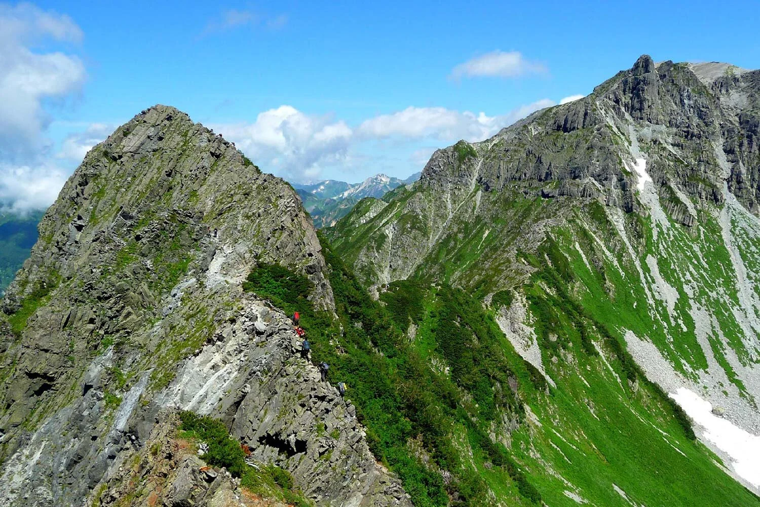
Follow the ridgeline today and be mentally prepared to take on the Daikiretto Gap. The other big feature today is summiting Yarigadake using metal ladders and chains. It will be a long day with the majority of the distance covering the descent. Big mountains summited today include Yarigadake (No.5 - 3180 m), Obami (No.10 - 3,110 m ), Naka (No.12 - 3,084 m), and Minami (No.17 - 3,033 m).


Related

Daikiretto Gap
This open section in the Northern Alps is considered one of the most exhilarating hiking feats in Japan.

Shugendo Buddhism
A religion unique to Japan that combines elements of religious tradition and mountain worship.

Japan’s Famous 100 Mountains
A list of 100 mountains that was selected in 1964 by the renowned Japanese mountaineer and author Kyuya Fukada.